






















Two Storms, One Ocean, Endless Questions
September in the Atlantic is living up to its stormy reputation. While hurricane watchers had already been tracking Hurricane Humberto, a newly named powerhouse storm swirling in open waters, eyes are now shifting southward. A disturbance dubbed Invest 94L is stirring in the Caribbean, with a high chance of earning the name Imelda in the coming days.
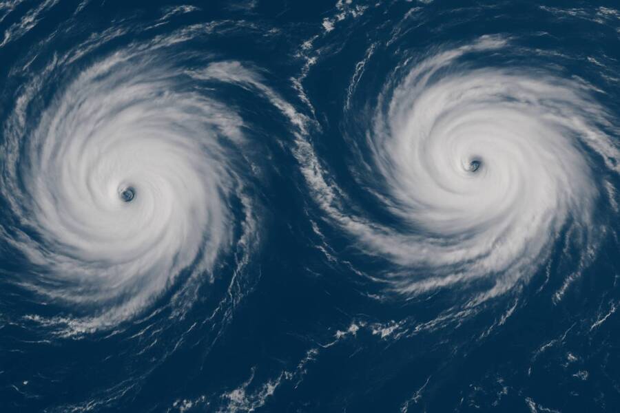
Two tropical systems spinning at the same time is not unusual during peak season—but what makes this setup fascinating (and worrying) is how they could interact. Sometimes, when storms get close, they don’t just pass each other by. They dance, tug. They alter tracks in ways forecasters struggle to predict. This phenomenon, known as the Fujiwhara effect, can turn forecast cones upside down overnight.
Add in record-warm ocean waters, shifting atmospheric patterns, and the undeniable influence of climate change, and you’ve got the makings of a complicated—and potentially dangerous—stretch of weather for millions along the Caribbean and U.S. East Coast.
In this article, we’ll break down:
-
Where Humberto is headed now and how strong it could get
-
Why Invest 94L could soon become Tropical Storm or Hurricane Imelda
-
The risks of storm-to-storm interaction
-
The climate backdrop making 2025’s storms more intense
-
Who needs to prepare, and how
1. Humberto: Already Flexing Muscle
Humberto didn’t waste much time. After forming earlier this week, it quickly organized into a tropical storm and then strengthened into a hurricane. The National Hurricane Center (NHC) forecasts steady strengthening, with models hinting Humberto could reach major hurricane status (Category 3 or higher) while still over the open Atlantic.
Current Track
At the moment, Humberto is spinning well east of the Bahamas, heading northwest. The good news: immediate landfall is not in the forecast. The bad news: long-range models diverge wildly. Some show it curving harmlessly out to sea. Others bring it closer to the U.S. East Coast, particularly the Carolinas or Mid-Atlantic, depending on steering currents.
What Humberto Means Now
Even without landfall, Humberto poses risks:
-
High surf and rip currents across much of the East Coast
-
Shipping and maritime disruptions in the Atlantic corridor
-
Erosion concerns for vulnerable coastal zones
And if Humberto intensifies more quickly than expected—a real possibility with record-warm sea surface temperatures—its reach could expand.
2. Imelda? Invest 94L Gathers Strength
While Humberto is hogging headlines, the real sleeper may be forming farther south.
The Caribbean Disturbance
Invest 94L is currently dumping heavy rain across the Dominican Republic, Haiti, and Puerto Rico. Forecasters estimate it has a 70–80% chance of becoming a named storm within the next 48 hours. If it does, the name waiting on the 2025 Atlantic list is Imelda.
Why Imelda Is a Wild Card
Unlike Humberto, which had open water to organize, Invest 94L is battling land interaction and pockets of wind shear. But once it emerges into the Atlantic proper, conditions look ripe for rapid intensification. That means Imelda could go from “disturbance” to “hurricane” in a matter of days.
And its track? Models are split. Some push it harmlessly out to sea. Others nudge it toward Florida, the Carolinas, or even the Gulf of Mexico depending on steering features.
3. When Storms Dance: The Fujiwhara Effect
Here’s where things get really interesting. If Humberto and Imelda grow close enough, they could begin influencing each other’s paths in what meteorologists call the Fujiwhara effect.
How It Works
Picture two spinning tops moving near each other on a table. Instead of colliding directly, they start orbiting around a shared center. Sometimes one absorbs the other, our they fling apart. One gets dragged closer to land when it wasn’t supposed to.
For forecasters, this is a nightmare scenario. Even small shifts in timing or intensity can dramatically change outcomes.
Why It Matters Now
-
If Humberto drifts west while Imelda strengthens, the two could interact.
-
If they remain far apart, each will follow its own course, sparing forecasters the headache.
-
If they interact strongly, forecast cones could flip within 24 hours, leaving coastal residents scrambling.
4. Climate Change and the 2025 Hurricane Season
It’s impossible to talk hurricanes in 2025 without talking about climate change. This season has already seen warmer-than-average oceans, and forecasters warned months ago that conditions were primed for above-normal activity.
Warmer Oceans = Stronger Storms
The Atlantic basin is running 1–2°C hotter than average in many spots. That may not sound like much, but it’s like adding jet fuel to the hurricane machine. Storms draw their energy from heat and moisture, and warmer seas mean more fuel for rapid intensification.
Rising Wind Speeds
A study earlier this year found Atlantic hurricanes have grown on average 18 mph stronger in sustained winds compared to just a few decades ago. That shift means more storms are reaching Category 3, 4, or 5, where destruction multiplies.
Changing Patterns
Atmospheric features like the Bermuda High and jet stream troughs also appear to be shifting. This changes where storms go—not just how strong they get. It may explain why more storms in recent years have threatened the U.S. Northeast and even Canada, not just the Gulf or Florida.
5. Who Should Worry? Risk Zones in Focus
Caribbean Nations
Right now, the Caribbean is under the gun from Invest 94L. Heavy rainfall, flash flooding, and mudslides are the main risks for the Dominican Republic, Haiti, Puerto Rico, and the Bahamas. Even before it’s named, this storm is dangerous.
U.S. East Coast
Both Humberto and Imelda could influence conditions along the East Coast, even if they don’t make landfall. Expect:
-
Dangerous surf from Florida to New England
-
Rip current advisories likely in place for days
-
Potential for tropical storm watches/warnings if tracks shift west
Inland Communities
Never forget: inland flooding is often the deadliest part of a tropical system. Even if Imelda arrives “only” as a tropical storm, it could drop 10+ inches of rain in pockets, overwhelming rivers and drainage systems.
6. Why Forecasting Is So Tricky Right Now
Even with satellite data, hurricane hunter flights, and advanced computer models, this week’s setup is especially challenging.
-
Storm interaction: If the Fujiwhara effect happens, models get messy.
-
Atmospheric steering: The Bermuda High could push storms west or steer them harmlessly out to sea. Small changes matter.
-
Rapid intensification: Warm water and low wind shear could turn Imelda into a hurricane faster than models can update.
-
Model spread: Beyond 5–7 days, forecasts are educated guesses.
The bottom line: don’t pin your hopes on one “cone.” Think of forecasts as scenarios, not certainties.
7. How to Stay Ready
Whether you’re in Florida, the Carolinas, the Caribbean, or even farther north, this is the time to review your storm plan.
Checklist
-
Supplies: 3–5 days of food, water, and medicine
-
Power backup: flashlights, batteries, phone chargers
-
Important documents: insurance papers, IDs, in waterproof bags
-
Secure property: bring in loose outdoor items, check shutters
-
Stay informed: follow NHC, local weather offices, and emergency management
Don’t Wait for Last Minute
Storm tracks shift quickly. If Imelda strengthens near the coast, warnings may come with less than 48 hours to act. Preparing early means you won’t be caught in evacuation traffic or empty store aisles.
8. Scenarios to Watch
To frame the uncertainty, here are four possible outcomes:
-
Both storms stay offshore: Humberto curves north, Imelda swings east—minimal U.S. impacts.
-
Imelda brushes the East Coast: Florida or the Carolinas could see tropical storm or hurricane conditions.
-
Fujiwhara effect kicks in: Humberto gets pulled west, raising landfall odds.
-
Merger: The storms combine, producing one larger, potentially stronger hurricane.
Any of these is possible. That’s why the next 5–7 days are critical.
9. The Big Picture: A Climate-Charged Future
The story of Humberto and Imelda isn’t just about two storms. It’s about what they represent: a future where back-to-back storms, rapid intensification, and chaotic interactions become more common.
For coastal communities, this means rethinking preparedness, infrastructure, and resilience. It means acknowledging that climate change isn’t a distant problem—it’s shaping hurricane seasons right now.
Conclusion: Stay Alert, Stay Ready
As September winds down, the Atlantic is heating up. Humberto is already flexing muscle as a hurricane, while Imelda lurks as a potential surprise. Their interaction could be dramatic—or they could spin harmlessly away.
What’s certain is this: uncertainty is the theme of the 2025 season. For millions across the Caribbean and U.S. East Coast, the best move is simple: stay alert, prepare now, and respect the forecast. Because when storms dance, the outcome is rarely predictable.

TechnologyHQ is a platform about business insights, tech, 4IR, digital transformation, AI, Blockchain, Cybersecurity, and social media for businesses.
We manage social media groups with more than 200,000 members with almost 100% engagement.